By Liu Yao
Through in-depth space cooperation, China and many countries in the world have jointly built a broad and magnificent "space silk road," contributing to the development and utilization of space resources and the progress of human civilization.
The constellation of the Beidou Navigation Satellite System (BDS) is working around the clock in the space. Since the system's commissioning more than three years ago, the application models of the BDS has been enriched, with its fields of application getting wider and wider.
According to statistics, the BDS-3 has provided accelerated positioning and high-precision service to more than 1.5 billion users in more than 230 countries and regions, winning more and more recognition from the international community.
In Xai-Xai, Gaza Province of Mozambique, there is a 20,000-hectare rice farm, the largest rice planting cooperation project in Africa. To plough the fields, and plant, manage and harvest crops on such a huge farmland was once a big challenge for local rice growers.
It was the innovation in agricultural technologies utilizing the BDS that benefited local rice growers. They can now control sprayer drones via mobile applications, thanks to the geographical positioning enabled by the Chinese positioning system.
Obtaining real-time geographical information through the BDS, sprayer drones are able to apply pesticides according to preset flight paths. Compared with traditional spraying methods, which rely on manual effort and can only cover a couple mu (667 square meters) each hour, BDS-enabled sprayer drones can treat over 100 mu of land every hour. Moreover, the drones can operate at night, dramatically improving efficiency.
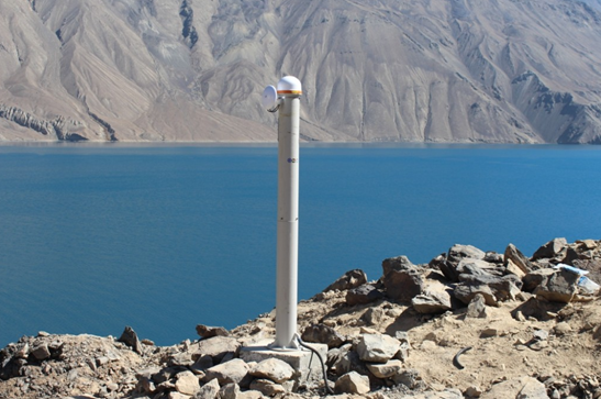
The Sarez Lake in eastern Tajikistan is the world's highest quake lake. It houses the highest and biggest natural dam in the world. Monitoring the deformation of the dam situated in a seismically active zone and thus protecting the safety of local residents remains an important issue.
A Chinese research team developed a deformation monitoring service platform for the dam based on the BDS, with a millimeter-level precision. With this platform, researchers can remotely monitor the deformation of the dam and send science-based warnings. The system has also been employed to monitor expressway side slopes in Kyrgyzstan and snow slides in Tajikistan.
According to Chen Gucang, deputy director of the China Satellite Navigation Office, the BDS is applied in a wide range of fields, and has played a significant role in the construction of the China-Kyrgyzstan-Uzbekistan highway as well as the operation of China-Kazakhstan crude oil pipeline and the China-Europe freight trains.
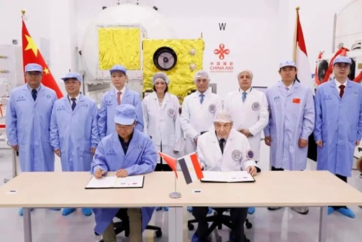
Two China-funded prototype satellites of the MisrSat II satellite project were delivered to the Egyptian side in June this year, making Egypt the first African country with the capacity to assemble, integrate and test satellites.
In December 2014, China and Egypt signed an agreement to carry out cooperation on the development of remote-sensing satellites. According to the agreement, China would build Egypt's first satellite assembly, integration and test center.
The two countries signed an agreement for the MisrSat II satellite project in January 2019, based on which China would provide the Egyptian side with a small remote-sensing satellite, a ground measurement and control station and a ground application system. Besides, China would also train Egyptian aerospace experts.
Prior to that, Egypt did not have its own satellite assembly, integration and test center, nor satellite development capabilities. It could only import complete foreign satellites. The completion of the China-funded center has provided Egypt with world-leading aerospace infrastructure.
Egyptian Minister of International Cooperation Rania Al-Mashat noted that these advanced technologies and equipment are important to not only Egypt, but also entire Africa.
China has established cooperation with many countries and regions in jointly developing and launching communication or remote-sensing satellites, as well as constructing satellite ground receiving stations and other space infrastructure. These efforts have played a positive role in the development of local sectors such as communication, agriculture, culture, environmental protection, and meteorology.
The China National Space Administration said that China is committed to promoting global technological progress and the sharing of innovative achievements, with an aim to enhance the capabilities of people around the world to explore and utilize space.
China always follows the principles of "peaceful use, equality, mutual benefit and common development." It is committed to transforming the Chinese space station into an open platform for international scientific and technological cooperation and exchanges.
Lin Xiqiang, a spokesperson and deputy director of the China Manned Space Agency, stated that the first batch of China's international cooperation projects in collaboration with the United Nations Office for Outer Space Affairs will soon conduct experiments on the space station. Additionally, the implementation of 10 space application projects in collaboration with the European Space Agency is also progressing in an orderly manner.
China's lunar exploration program has opened up opportunities for international cooperation on Chang'e-8 to the international society. It welcomes countries and international organizations to join and carry out multilevel collaboration together to achieve more major original scientific discoveries.